Low-emission zones are zones where the most polluting vehicles are forbidden from driving. Zones are intended to improve air quality and so public health.
Criteria to enter in a zone are different according to the countries:
- Some countries use an emission sticker. Only vehicles with an authorized emission sticker can enter the area.
- Some countries use the emission standard. In this case, no emission sticker is required for the vehicle. The access criteria for driving in low-emission zones depend on the category, fuel and euro norm of the vehicle.
- Some countries combine the two different systems. In this case, some zones of the country use emission stickers while others are based on the emission standard criteria.
- Additional notes:
- The displayed low-emission zones reference an area. Zones, which reference single road segments, are not displayed, but the Position Matching of Map Matching API can provide this piece of information for these segments.
- The PTV Developer Vector Maps API provides low-emission zones across the world, whereas the Routing API considers low-emission zones in Europe, only.
API endpoint
You need the following API endpoint to request low-emission zones:
https://api.myptv.com/maps/overlays/v1/vector-tiles/Request
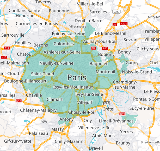
For a single tile showing Paris, France specify the map tile path with zoomLevel, x and y as shown below.
You can test this by entering the URL into your web browser. Be sure to replace YOUR_API_KEY with your actual API key.
https://api.myptv.com/maps/overlays/v1/vector-tiles/11/1037/704?layers=lowEmissionZones&apiKey=YOUR_API_KEYResponse
The call result is a single map tile in MapBox Vector Tiles format.
Tile content
The requested vector tile contains data which is listed in this table. The individual columns are explained below.
| Name of content | Type | Description |
| geometry | SRID 3857 | |
| zone_name | text | Name of the zone, contains the name of the city or region in that the emission zone is valid. |
| approvals | text | Comma-separated list of approvals to enter the zone. Usually, such approvals are environmental badges to be placed on the windscreen, but it can also be any other kind of approval or vehicle registration allowing it to enter a low-emission zone. This list can be changed at any time, clients should handle unknown values properly. |
| categories | text | Comma-separated list of vehicle categories to which the low-emission zone restrictions apply. |
| fuel_types | text | Comma-separated list of fuel types to which the low-emission zone restrictions apply. |
| time_dependent | boolean | If true the emission zone is time-dependent. That means that the restrictions are only applied during a certain time period. Some emission zones are permanent and time_dependent is false. |
| iso_country_code | char | Contains a three-character country code. Examples are deu for Germany or fra for France. You can find more information about this code here: https://en.wikipedia.org/wiki/List_of_ISO_3166_country_codes |
Approvals
Available values are: NONE, AT_EURO_1, AT_EURO_2, AT_EURO_3, AT_EURO_4, AT_EURO_5, AT_EURO_6, DE_GREEN, DE_YELLOW, DE_RED, DK_AUTHORIZED, ES_CAT_B, ES_CAT_C, ES_CAT_ECO, ES_CAT_ZERO, FR_CRITAIR_0, FR_CRITAIR_1, FR_CRITAIR_2, FR_CRITAIR_3, FR_CRITAIR_4, FR_CRITAIR_5, MX_HOLOGRAMA_0, MX_HOLOGRAMA_00, MX_HOLOGRAMA_1, MX_HOLOGRAMA_2, MX_HOLOGRAMA_EXEMPT, MX_HOLOGRAMA_FOREIGN.
Categories
The possible value range is ALL_VEHICLES, MOTORCYCLE, CAR, DELIVERY_TRUCK, TRUCK, BUS, TAXI, CARPOOL, THROUGH_TRAFFIC.
Fuel Types
The possible value range is GASOLINE, DIESEL, COMPRESSED_NATURAL_GAS, LIQUEFIED_PETROLEUM_GAS, LIQUEFIED_NATURAL_GAS, NONE.
Styling
Low-emission zones are shown as half transparent green polygon. The layer name is TSP_Low_Emission_Zones.
How to implement
The tutorial on how to integrate overlays into a Vector Map also addresses low emission zones.