When using map tiles, the displayed map is not requested as a single image but assembled from several map tiles. The client application only requests the map tiles needed for the current map view. Whenever the map view changes by zooming or panning, the application only has to request the tiles that come into view instead of the entire map.
Identification of Map Tiles
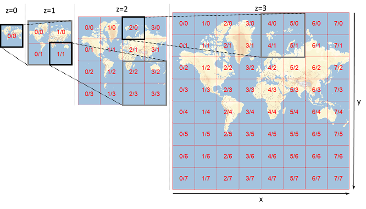
- Every map tile belongs to a zoom level z=0, 1, 2, 3 and so on. These levels are related to each other by a factor of two in scale. The zoom level also determines how many tiles are needed to display the entire world. At z=0 the entire world is displayed in a single tile. At z=1, 2*2=4 tiles are needed to display the entire world, and so on.
- Every map tile is uniquely identified by the triple z/x/y consisting of the zoom level z and the coordinates x (horizontal) and y (vertical).
- The coordinates x and y range from 0 to 2*z-1. So zoom level z=0 consists only of the tile 0/0/0. At z=1, the four tiles are 1/0/0, 1/0/1, 1/1/0 and 1/1/1. The tile z/0/0 is always the top left tile of the respective zoom level.
Projection and Coordinate System
Displaying the (approximately ellipsoidal) surface of the earth on a flat surface, such as a computer screen, requires the use of a projection. The Vector Maps OSM service uses the Web Mercator (EPSG:3857) projection, which is the de-facto standard for web mapping. It is based on the WGS84 coordinate system.